 New South Wales Consolidated Regulations New South Wales Consolidated Regulations
(Clause 17)
(1) This Division applies to land shown edged heavy black on the locality plan below named "Springwood Precinct RP-SP01--St Columba's Elmhurst Precinct" and shown by distinctive bordering and designated RP-SP01 on Map Panel A.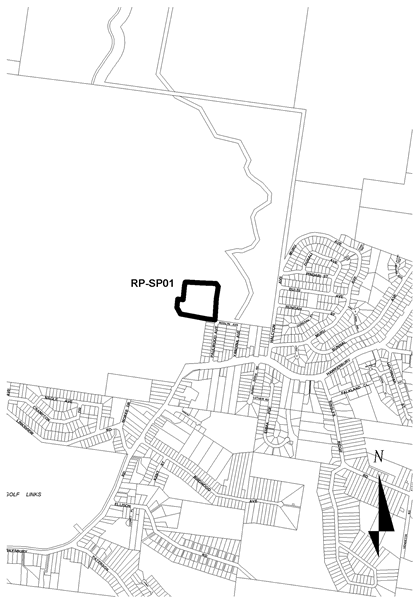
(2) Consent must not be granted to development within the Springwood Precinct RP-SP01 unless the development proposed to be carried out--(a) complies, to the satisfaction of the consent authority, with the precinct objectives in achieving the precinct vision statement within this Division, and(b) complies with the building envelope within this Division, and(c) is consistent, to the satisfaction of the consent authority, with the design considerations within this Division.
(1) Precinct vision statement Located on the periphery of the urban areas of Springwood and Winmalee, this site is significant for its natural and cultural values. The precinct forms part of a site comprised of land with high environmental value, including escarpment areas, areas of steep slope, riparian corridors and significant vegetation. In addition, the site contains valuable evidence of pre-1890 Aboriginal habitation. These areas are protected through a conservation management plan. Watercourses on the site feed into the Hawkesbury-Nepean catchments. All of these factors impact on development within the precinct. The precinct contains important heritage items that relate to European settlement at the turn of the 20th Century. Development within the precinct retains a predominantly rural setting around the "Elmhurst" building and is of a scale and form that is complementary to the historic form of "Elmhurst". The environmental values of the site are protected through appropriate development and design and mitigate the impact on adjoining land zoned Environmental Protection and sub-catchments of the Hawkesbury-Nepean River. Development incorporates appropriate siting and design that addresses the level of bush fire threat.
(2) Precinct objectives(a) To ensure the impact of development on the environment is minimised through appropriate design and management.(b) To ensure development incorporates appropriate siting and design that address the level of bush fire threat.(c) To provide for the conservation and management of significant heritage features.(d) To provide a range of uses that are compatible with community access.
(1) Building height(a) Buildings are not to exceed a maximum building height of 8 metres or a maximum height at eaves of 6.5 metres.(b) Notwithstanding paragraph (a), the consent authority, in assessing building heights, is to have regard to the recommendations of a conservation management plan.
(2) Building setback(a) The minimum setback from the primary access road, as existing on the appointed day, to the west of the precinct is 40 metres.(b) The consent authority, in assessing setbacks from heritage buildings, is to have regard to the recommendations of a conservation management plan.
(3) Site coverage(a) The maximum site cover for buildings (including any buildings ancillary to the main building, swimming pools or tennis courts) is 30 per cent of the total area of the precinct.(b) The minimum area to be retained as soft, pervious or landscaped areas (excluding hard surfaces) is 40 per cent of the total area of the precinct.
(4) Development density(a) The maximum floor space ratio for development is 0.35:1.(b) For the purpose only of this subclause,
"floor space ratio" means the ratio of the total gross floor area of all existing and proposed buildings within the precinct to the area of the precinct.(c) Notwithstanding paragraph (a), the maximum floor space ratio is permissible only where the consent authority is satisfied, after considering the conservation management plan, that the integrity of the heritage items on the site will be maintained.(d) Notwithstanding paragraph (a), the maximum floor space ratio is permissible only where the consent authority is satisfied that appropriate bush fire management measures are in place in accordance with this plan.
(1) Consent must not be granted unless the consent authority has considered the following--(a) a bush fire threat analysis that, to the satisfaction of the consent authority, assesses the threat of bush fire and incorporates appropriate recommendations for the design of the proposed development siting and addresses the level of bush fire threat,(b) an archaeological survey undertaken to determine the location and significance of any archaeological sites and any Aboriginal places on the land, and a report on how development should be managed with regard to the result of the survey,(c) a detailed heritage impact assessment and conservation management plan,(d) how development in this precinct will have regard to and complement the existing historical and heritage values of the site,(e) a traffic statement, prepared by a suitably qualified traffic engineer, which addresses but is not necessarily limited to an assessment of increases in traffic volumes, the impact of proposed development on Hawkesbury Road, and the number and location of car parking spaces,(f) how significant street trees along the primary access road are to be retained and appropriate measures for their protection,(g) a statement of community benefit, indicating recommendations for the provision of and access to public facilities on site.
(2) A minimum of 2 separate vehicular access routes shall be provided from the precinct to Hawkesbury Road.
(3) New buildings shall be separate and independent from the primary school grouping.
(4) Development adjacent to "Elmhurst" shall provide frontages in a westerly direction.
(5) A variety of heights and forms shall be incorporated in the design of development in order to minimise the bulk and scale of development and shall be of a form that is complementary to the historic building within the precinct.
(1) Building height Buildings are not to exceed a maximum building height of 8 metres or a maximum height at eaves of 6.5 metres.
(2) Setback The minimum setback from a road reserve is 8 metres.
(3) Site coverage(a) For any allotment having an area of less than 1,000 square metres the maximum site cover for buildings and buildings ancillary to the main building (excluding water tanks) is 30 per cent or 160 square metres, whichever is the greater.(b) For any allotment having an area of 1,000 square metres or greater, the maximum site cover for buildings and buildings ancillary to the main building (excluding water tanks) is--(i) 300 square metres, and(ii) an additional amount equivalent to 10 per cent of the amount by which the site area exceeds 1,000 square metres, but not exceeding 100 square metres.(c) Consent may be granted for development that does not comply with the maximum site cover in subclause (1) or (2), but only where the development includes measures designed by a suitably qualified person to improve stormwater management, such as infiltration measures and detention systems, that demonstrate that the development has a beneficial effect on stormwater quality, quantity and flow characteristics.(d) The minimum area to be retained as soft, pervious or landscaped areas (excluding hard surfaces except for water tanks, unenclosed areas of spaced decking and swimming pools) is 60 per cent of the total allotment area.
(4) Development density The maximum floor space ratio for development is 0.4:1.
(1) This Division applies to land shown edged heavy black on the locality plan below, named " Leura Precinct RP-LE01--Former Golf Clubhouse Precinct " and shown by distinctive edging and annotated "RP-LE01" on Map Panel A (referred to in this Division as the
"Former Leura Golf Clubhouse Precinct" ).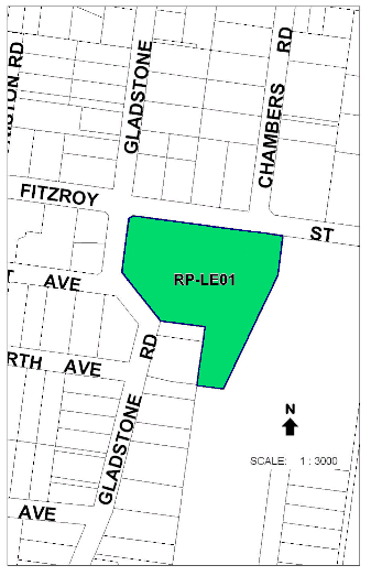
(2) Consent must not be granted to development on land to which this Division applies unless the proposed development--(a) is consistent, to the satisfaction of the consent authority, with the precinct objectives in achieving the precinct vision statement set out in clause 2, and(b) complies with the building envelope requirements set out in clause 3, and(c) complies with the character preservation requirements set out in clause 4, and(d) is consistent, to the satisfaction of the consent authority, with the design considerations set out in clause 5.
(1) Precinct vision statement Formerly the site of the Leura Golf Clubhouse and Bowling Club, which has its origins in the early twentieth century, the Former Leura Golf Clubhouse Precinct is in an area of Leura recognised for its streetscape character, landscaped garden setting and areas of older housing. The site has a prominent position on the tourist route between the Leura town centre and Sublime Point.
Development in the precinct accommodates accessible housing and a range of services and facilities to meet the needs of residents. Future housing development should contribute to providing a quality living environment for older people, with access to necessary services and facilities. As the focal element of the precinct, the former Leura Golf Clubhouse should be retained as a facility for residents and in recognition of its contribution to the streetscape.
The precinct contributes to the character of the locality by establishing a landscape setting and gardens within building setbacks and common open space. Buildings respect the scale and architectural form of surrounding development through articulated roof forms and floor plans and by presenting a generally single-storey appearance.
(2) Precinct objectives(a) To enable the provision of accessible housing with a building form and scale consistent with residential character in the locality and utilising the facilities provided by the former Leura Golf Clubhouse.(b) To ensure the retention and enhancement of the former Leura Golf Clubhouse for use as a community facility and in recognition of its contribution to the streetscape character of the locality.(c) To minimise the impact of development on the environment and on residential amenity through appropriate siting and design of buildings.(d) To maintain and improve streetscape character by establishing a landscaped garden setting, consistent with the settings of residential and other land uses in the locality.
(1) Building height(a) A maximum building height of 6.0m and a maximum height at eaves of 4.5m applies to any building--(i) fronting Fitzroy Street, or(ii) that is on a lot adjoining the Living--Conservation zone if the building, or any part of the building, is within 12m of the boundary with that zone, or(iii) within 50m of the southernmost boundary of the Former Leura Golf Clubhouse Precinct.(b) A maximum building height of 8m and a maximum height at eaves of 6.5m applies to any building other than a building specified in paragraph (a).(c) The height of a building fronting Fitzroy Street may be measured from the finished ground level of the bowling green (rather than from street level)--(i) if measuring from that level is necessary to preserve the landscape setting of the building or to enhance the relationship of the building to Fitzroy Street by limiting the visual prominence of its roof structure, and(ii) provided that the building will have a single-storey appearance from Fitzroy Street.
(2) Building setback(a) Buildings fronting Fitzroy Street must have a setback of not less than 12m and not more than 15m.(b) Buildings fronting Gladstone Road must have a setback of not less than 8m.(c) No buildings may be located between the former Leura Golf Clubhouse and Fitzroy Street, in an area extending 10m from the outermost walls of the Clubhouse.(d) A building on land that adjoins the Living--Conservation zone or the golf course must have--(i) if the building has a building height of 6m or less--an average setback of not less than 4.5m, or(ii) if the building has a building height greater than 6m--an average setback of not less than 6m.(e) A building may only be located within 50m of the southernmost boundary of the Former Leura Golf Clubhouse Precinct if the building--(i) has a setback of at least 10m from that boundary, and(ii) maintains adequate view lines from each adjoining property on land in the Living--Conservation zone to the golf course, and(iii) contains no more than two dwellings, and(iv) provides a transition in terms of bulk, scale and form between development within the precinct and the housing forms on land in the adjoining Living--Conservation zone.
(3) Site coverage(a) Except as provided by paragraph (b), the maximum site coverage for buildings (including ancillary buildings, swimming pools and tennis courts) is 30 per cent of the total precinct area.(b) The maximum site coverage for buildings located within 50m of Fitzroy Street is 1,000 square metres (excluding the site coverage of any building existing on the appointed day).(c) The minimum area to be retained as soft, pervious or landscaped areas (excluding hard surfaces) is 55 per cent of the total precinct area.
(4) Development density(a) The maximum floor space ratio for development is 0.4:1.(b) When calculating floor space ratio for the purposes of paragraph (a), the consent authority may exclude up to 50 per cent of the gross floor area of the former Leura Golf Clubhouse (calculated as at the appointed day) in order to encourage the retention of the Clubhouse as a common facility for residents and an integral component of the streetscape.
(1) In its consideration of the matters set out in Division 3 (Character and landscape assessment) of Part 3 of this Plan in connection with an application for consent to carry out development for the purposes of a building fronting Fitzroy Street, the consent authority must consider whether the building will reflect architectural features that are typical of Blue Mountains cottages.
(2) Buildings fronting Fitzroy Street must--(a) have an individual dwelling identity and street address, and(b) not exceed 15m in width or depth, and(c) have a landscape setting that enables planting to the front and sides of each building, and(d) incorporate articulated floor plans and roof forms, and(e) incorporate shady eaves and verandahs.
(3) Development on land in the Former Leura Golf Clubhouse Precinct must not have a detrimental effect on the contribution of the former Leura Golf Clubhouse to the streetscape and character of the locality.
(4) Consent for development on land in the Former Leura Golf Clubhouse Precinct may be granted subject to a condition that requires the creation of a restrictive or positive covenant that provides for the retention and continued maintenance of the former Leura Golf Clubhouse, but this subclause does not--(a) limit the kinds of conditions that may be imposed on a development consent, or(b) allow conditions to be imposed on a development consent otherwise than in accordance with the Act.
(5) Consent must not be granted for development involving the demolition of the exterior, or part of the exterior, of the former Leura Golf Clubhouse unless the consent authority is satisfied that the building, or part of the building, proposed for demolition, is--(a) structurally unsound (on the basis of documentary evidence), and(b) not economically repairable (on the basis of documentary evidence prepared by a suitably qualified person that demonstrates that the cost of the repair would exceed the value of the repaired building).
(1) Built form and landscape setting(a) Built forms must provide a transition from larger buildings in the centre of the Former Leura Golf Clubhouse Precinct to domestic scale cottages, as viewed from the golf course and any public place.(b) Except as provided by paragraph (c), buildings must have pitched tiled roofs, with materials and form that complement the former Leura Golf Clubhouse.(c) Low pitched decked roofs are permissible to internal roof areas of buildings if they are not visible from a public place or from adjacent properties.(d) Soil within the Fitzroy Street front building setback must be remediated to provide a deep planting zone, which must be planted to provide a garden setting that will make a significant contribution to the streetscape within 10 to 15 years.(e) Buildings should reflect the principles of water sensitive urban design.(f) A landscaped screen sufficient to separate the site from existing residential properties on land in the Living--Conservation zone and the golf course must be provided along the perimeter of the shared boundaries.(g) Buildings must not reduce solar access below 3 hours between the hours of 9am to 3pm on 21 June for any dwellings existing on the appointed day.(h) A variety of heights and forms must be incorporated, and varied setbacks encouraged.
(2) Vehicular access(a) Vehicular access to the precinct must be limited to a single point of access to Fitzroy Street.(b) Vehicular access, parking and garages for dwellings fronting Fitzroy Street must be located to the rear of the former bowling green to minimise visibility from the street.
The maximum building height is 8 metres and the maximum height at eaves is 6.5 metres.
The front wall of a building shall be set back from the road reserve a distance of not less than 8 metres.